Showing posts with label aviation. Show all posts

Monday, December 5, 2016

Part 1: Existing 3D Support in WhirlyGlobe-Maply

We've got a two parter for you.  First up we'll look at the existing 3D support in WhirlyGlobe-Maply.  Next time we'll lay out the roadmap for 3D in the future.

So let's start with the question:  Isn't WhirlyGlobe-Maply already 3D?

3D Minus 1D Equals 2D


Everything WhirlyGlobe-Maply does is 3D, but we hide it most of the time.  Look at some of the more prominent apps, even ones that use the globe.

Dark Sky, Gaia GPS, NatGeo World Atlas

The giveaway is the gestures.  Can you tilt?  Nope.  And we're not hiding some wealth of information.  If you did tilt toward the horizon you'd see.... nothing much.

To be truly 3D an app needs to turn on the 3D gestures and it needs data with real 3D structure.  There are a few that do it and we provide a lot of functionality to support them.

LIDAR Point Clouds


Did you know WhirlyGlobe-Maply supports LIDAR in a pageable sqlite format?  It does and it's pretty cool.


Available on both iOS and Android in 2.5 this is an essential use of 3D.  You couldn't see all that much in 2D... well okay you can, but it's better in 3D.

Truly 3D Terrain


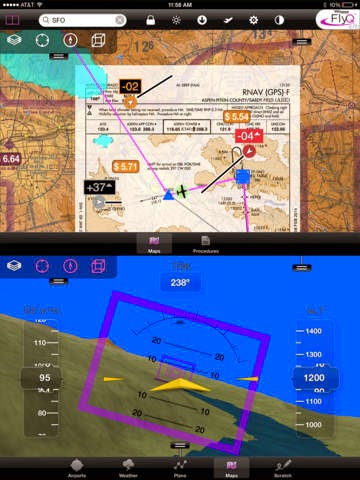
We've been able to do true 3D terrain for years.  Aviation apps use it.

FlyQ EFB Synthetic Vision Mode

Why don't you see that more?  Well, it's useful for aviation and.... um, games maybe?  Users tend to be specialized.

Models, Markers, Billboards, Labels & Lines


The toolkit can display 3D models in Wavefront OBJ, a data format old enough to vote, but it works well enough.

We can also do billboards, which are like a 3D version of markers and, of course, labels.  Here's what you'd use that for.

NATS Airspace Explorer


Inspired to make your own 3D traffic app?  Of course you are, but it's a lot of work to get the display right and the data is expensive.

General 3D Geometry


Lots of our users make stuff up on the fly.  Why?  Because if there was a pre-packaged version of it, they wouldn't be making an app.

Fake airstrips are fake.  Do not try to land.

For stuff like this we've got a model generator.  You build up your special snowflake of a model polygon by text by line as needed.

If you've already got 3D geometry, you can hand the triangles over to the renderer.  Hard core, but useful in a few cases.

Lofted Polygons and Extrusions


On the easier side are a couple of features that let you think in 2D and tack on a height.

Downright candy colored

Lofted polygons have been around a long time and work well on the globe.  They're nice for showing relative height... and they just look cool.

Extrusions are a way of whipping up a model without having to do, like, math.  You can slap together an arrow, for example, to point at things.

Where We're Heading


WhirlyGlobe-Maply has extensive 3D support and real apps (mostly aviation) have been using it for years.  It's all rather do-it-yourself though, particularly on the data side.

There are a number of good data sources for 3D coming on line recently.  In the next post we'll discuss how we'd like to use them and where we'd like to go.

Wednesday, August 24, 2016

Announcing WhirlyGlobe-Maply Imagery Pro

Today I'm delighted to announce the first option on top of the WhirlyGlobe-Maply toolkit: Imagery Pro.

The red's moving away so that's good.

Up to now everything has gone into the free toolkit or client apps.  This marks the first time we're keeping something to ourselves and, yes, charging for it.

Who's This For?


We love all our users equally.  Okay, maybe we love the ones who pay support a little bit more.  But you're all cool.  Honest.

We've attracted a lot of weather and aviation users.  It makes sense.  They have pretty serious data display needs and only a passing interest in street maps.

Imagery Pro is for them.  We're taking what we've learned and pushing way beyond.

What's In It?


It's all in the marketing, but the basics are like so:

  • Efficient data transport
  • Fancy shaders
  • Getting rid of the !#*$& seams
  • Easier particles
I do love my animated gifs

All good stuff if you do weather and/or aviation.

So what about WhirlyGlobe-Maply?


That's right.  My five year plan to give away massive amounts of geospatial code is finally coming to fruition!

But no, the base toolkit is all good.  Imagery Pro is about expansion into a couple of markets that want much more right now and they're willing to pay for it.

We're continuing to expand WhirlyGlobe-Maply with iOS (2.5) and Android releases in the pipeline.  That's not going to change.

Monday, April 20, 2015

Old App: FlyQ EFB

Purple rectangles are common at altitude
This is an oldie, but I've just gotten permission to disclose it.  Introducing FlyQ EFB from Seattle Avionics.

Seattle Avionics is actually one of my oldest clients and theirs are among the most complex WhirlyGlobe-Maply apps around.  I've finally talked them into going public with their support for open source!

FlyQ EFB


For those of you unfamiliar with aviation terms (guilty) EFB stands for "Electronic Flight Bag."  

Pilots used to haul a ton of paper charts around and do all sorts of complicated things with them.  PCs and specialized devices replaced much of that and now commodity tablets are changing things again.  Just like in other markets.

If you've ever wondered why WhirlyGlobe-Maply seems to have so many aviation-friendly features, now you know.

Maps, Globes, and True 3D


In FlyQ EFB WG-Maply is largely used as a map.  Even though it's on a globe, everything is plastered to the surface and interactions are almost entirely map like.  

Don't let me anywhere near the controls of a plane.

All of the objects you see on the globe are standard things like screen markers, labels, image layers and so forth.  Organizing the data and passing it to WG-Maply is accomplished in the app, and I can assure you, that's the hard part.


Orange is bad.  It's not orange's fault.

There's also a true 3D mode which is meant to resemble what a pilot might actually see with certain caveats (Look out the window, fool).  This is a little further afield of what WG-Maply is meant for and is tied much more tightly to their app.

Smart Plates & Charts


Seattle Avionics has another app called SmartPlates & Charts.  Think of it as a simpler sibling to FlyQ EFB.  If you're just curious, I'd start here.


It's great to be publicly welcoming Seattle Avionics to the open source family!  If any of you other lurkers want to fess up, let me know.