Showing posts with label vector map. Show all posts

Friday, January 11, 2019

Saildrone Forecast

Is there anything cooler than shipping an app you've spent a year and a half working on?
It was a rhetorical question.  There is not.


Saildrone Forecast

Hint: It's a weather app.

Saildrone Forecast


Yup, Saildrone Forecast is a weather app.  Just watch the video.


Go download it.  I'll wait.

Technical Bits


There's a ton of stuff in Saildrone Forecast that's unique.  But there are a couple bits of interest in WhirlyGlobe-Maply itself, like the new sampler/loader architecture and offscreen render targets.  Go watch the video.


Could you make your own weather app out of the box now?  Ha ha.  Oh god no.  There's so much other stuff to do.  Not to mention the data.  But there are cool things to do with the vector maps and render targets.

Acknowledgements


I didn't do this all alone.  Heck, I didn't even write the whole app. 

Credit goes to Logical Animal for the rest of the UI.  Big thanks to the meteorology/modeling team at Saildrone for the data and putting up with stupid questions.  Thanks to the platform developers and ops for processing data and keeping it running.  And, of course, management and finance upon whom I can bestow the greatest contracting honor:  They always pay early.

Friday, May 13, 2016

Integration with Micello Indoor Maps

A few months ago we were approached by Micello about displaying their indoor maps in WhirlyGlobe-Maply.  They provide indoor maps to a ton of interesting companies.

Taste the Capitalism!

Seemed like an excellent idea so we went ahead and whipped up a tutorial and demo.

Micello Tutorial


Micello was kind enough to provide a few examples.  We chose the Westfield Valley Fair mall near Cupertino.  I used to live there and have a certain fondness for it.  There was also a recent story about the minimum wage change that cut right through the mall which we incorporated into the display.


If you've got a Micello account feel free to work through the tutorial and let us know if you have nay questions.

On To the Future!


Ranen put together a rather nice example app, which is what you build in the tutorial.  It shows off some fairly clever display with styles, selection and a few other things.  But we could do more for optimization, label layout, and general display flexibility.

Our example was built on the globe, but you could as easily put it on a regular map.  Doing something special for pure indoor map display is also an interesting idea, though this seems to work well enough.

WhirlyGlobe-Maply is an open source toolkit, so you can take the code and run with it.  Feel free!  But we do consulting if you've got a budget and some requirements.

Tuesday, March 29, 2016

Map Features in WhirlyGlobe-Maply

I'm going to discuss map related features of the WhirlyGlobe-Maply toolkit. The SDK is an open source, mobile centric geospatial display toolkit. It’s used in a variety of weather, aviation, geography and map apps.

Two of the more prominent examples are Dark Sky, a weather app and National Geographic World Atlas, which is exactly what it sounds like.

NatGeo World Atlas & Dark Sky

The globe apps are best known, but WhirlyGlobe-Maply has huge support for traditional 2D map apps too.  We're going to talk about some of those features, but let's start with map apps in general and one in particular.

Map Apps


Mapping is one of the more popular categories in the app stores. Both Apple and Google have their own map offerings and toolkits, but they're poor if you have your own data? That’s where toolkits like WhirlyGlobe-Maply come in and we’ve built a number of features specifically for those sorts of apps.

One of the more capable map apps that uses the toolkit is Gaia GPS.

Fact: 30% of hiking app screenshots are Yosemite.

Gaia GPS displays a variety of image and vector based data sources. It’s popular among the backpacking and off roading communities.  It can work without a network and is very careful with battery.

Let’s move on to one of the key features for nearly every map app: Image Tiles.

Image Tiles


A basic feature required for map display is loading and rendering of image tiles. We’ve moved well beyond Web Map Service on mobile devices and we now expect tiles. This might be a Web Map Tile Service (WMTS), but is more likely to be a fixed quad tree of tiles like that coming from Google Maps or OpenStreetMap.


Efficient image tile loading is a tricky problem. Mobile devices have network constraints and we want to make careful use of data caching. WG-Maply can handle this for both globe and map, but there’s an interesting variant for the map case.


In the example we’re loading three levels of tiles based on the current window. We start with an extremely low resolution, then overlay that with slightly higher resolution and finally toss in the proper resolution. It gives the user something to look at while the system loads the good stuff.

Tricks like these are important to efficient map display on mobile, but let’s take a quick detour through some really basic functionality.

Vectors, Labels and Markers


Any credible map toolkit should be able to display some basic features and WhirlyGlobe-Maply is no exception. These include vectors for areal and linear features, labels for points and of course markers.


All very simple to us.  Vectors, for example can be consumed from a variety of data sources, like GeoJSON or (ESRI Shapefile). Labels and markers are 2D features and can interact through an adaptive layout engine.  All of them provide selection feedback too.

It’s what the developers do with these features that gets interesting. That leads us to a complex modern feature: vector tiles.

Vector Tiles


Mapbox has popularized vector tiles with their OpenStreetMap data set. Theirs is a Google Protobuf based format, which is as complex as it sounds. The fundamental ideas are simpler.

Vector tiles are to image tiles as vectors are to images. They are just chopped up geometry representing what’s in each map tile. You can use them much more flexibly than images.

A very custom example of vector tiles.
Believe it or not, National Geographic World Atlas uses vector tiles hosted by Mapbox.  The rest of it is completely custom.  And, okay, it's technically a globe.  But if National Geographic doesn’t have some cartographic street cred, nothing does.

A more normal use of vector tiles.

The Gaia GPS developers use vector tiles they generate themselves to draw contour lines. The data is styled using Mapnik XML which is associated with the Mapnik map renderer.  Gaia GPS also has a street layer based on the same approach.

WhirlyGlobe-Maply has vector tile support down solid, but style support is still in flux and likely to be for a while. We can support older style formats like Mapnik XML and developers can always go off on their own. Newer formats like Mapbox GL Style Sheets are not fully supported yet. We also hope to add in Styled Layer Descriptor since it's an actual standard.

Vector Tiles are a bit trippy so let’s go back to some more basic map features.

Wide Vectors


Widened vectors are one of those obvious things that require some work to implement.  OpenGL ES has a basic line implementation, but it looks kind of... meh.  If you want lines that have smooth edges and neat little joins, you need something more.


WhirlyGlobe-Maply's implementation involves a custom OpenGL ES shader and a bit of math.  Line intersections are calculated on the fly (sort of) and width can be varied as needed.  Typically this just looks like constant width lines as the user moves in and out.

Look deep into my shader
Oh, and you can do dashed lines and other effects.  Wide vectors work both on the flat map and the globe, but they're primarily a map feature, just like the next one: clustering.

Marker Clustering


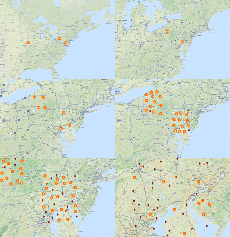
Clustering markers is a pretty simple idea. When you have a lot of markers on your map, it can look bad. Best to gather them up into groups and display the groups.


Simple enough, but our maps move so we have to do something more. As the user zooms in, the groups come apart and as zoom move out, the groups form. It’s tricky to implement, but looks quite nice.


In truth, clustering can be used on both the globe and the map even it’s nominally a map feature. Let’s look at something purely from the 2D map.

Infinite Scrolling


For certain types of map projections, the extreme west and east extents represent the same point (really, line). This means the user expects to move the map and have it wrap around.

Bonus question: What about wrapping top to bottom?

Infinite scrolling is simple in concept, but tricky to implement. The rendering isn’t bad, but when you add in feature selection and overlaid data it gets interesting. You know what else is interesting? Map projections.

Map Projections


The real test of a map toolkit is whether it handles explicit map projections. Actually, that’s not true. Plenty of map toolkits only work in a simple map projection, known as web mercator. But if you want to hold your head high in a room full of cartographers, you should have map projection support.

Does this projection make my poles look big?

Web mercator, shown here, is the most common projection in use on mobile. It has its problems, particularly near the poles. We can thank Google Maps’ dominance for this affront to cartography.  There's data in plenty of other projections and good reason to use them.


From left to right we’ve got:
  • A data source in British National Grid overlaid on a web mercator map.
  • The same data source overlaid on a British National Grid map. The web mercator data source is being reprojected.
  • The same thing on a globe. Because it looks cool.
Though the vast majority of our users will always use web mercator, WhirlyGlobe-Maply can do more. It uses the Proj.4 coordinate system package internally and can handle a variety of useful map projections.

Conclusion


Map toolkits for mobile devices are hot right now. There are a number of excellent ones, though most are tied to specific data services like Apple or Google or are proprietary or both.  A few are open source, like WhirlyGlobe-Maply.

We’ve discussed some basic features and a few advanced ones we consider essential for map display on mobile. If you’re looking to build an app, we hope you’ll look beyond the proprietary services to something like WhirlyGlobe-Maply.

Special thanks to Stamen for the Stamen Watercolor map tiles, derived from OpenStreetMap data, used in many of these examples.

Friday, March 4, 2016

CartoType GL

In cooperation with CartoType Ltd, I am proud to announce CartoType GL for iOS and Android.

Parks are green!

CartoType GL is the next generation of the CartoType map toolkit.  It's got all the flexibility of the existing library for map representation, routing and address searching, but we've add a zippy OpenGL ES renderer.

What is CartoType?


CartoType is an offline map library that works with limited resources.  This makes it popular on smartphones and other situations where the user is not connected to a network.  It can handle a variety of data inputs, making it easy to use your own data, but can also deal with the usual OpenStreetMap cases.

I wonder where this is?

The existing CartoType library does a really nice job representing complicated maps in a very small space.  It's primarily a static map rendering library, so when you use it on a smartphone it'll render the map when you stop moving.  What we've done is upgrade the renderer.

What is CartoType GL?


CartoType was already doing a fine job representing maps.  What it needed was to draw them faster.  CartoType GL is just what it sounds like, an OpenGL ES based version of CartoType that solves the speed problem.


CartoType GL marshals the resources of the existing library to convert data to internal vector tiles.  Those are are processed into OpenGL ES compatible data and rendered at a nice zippy, interactive speed.  Basically just what you'd expect in a modern map toolkit.

Online vs. Offline


There are some excellent cloud based map solutions out there for map representation, routing, address searching and so forth.  CartoType GL is not that; it's an offline solution.

I have no idea where this is.

Why offline?  Well, it's actually a different problem.  You can cobble together offline solutions from the online technology, but they're not great.  They're too big, they don't do routing well and they're focused on display.  If you want to do a good offline map toolkit it's a different beast.  That's what CartoType is.

Cost & Availability


CartoType GL is, logically enough, being sold through the CartoType company.  They are the ultimate source of details on this effort.  Contact them for a license.

We hope to get the iOS version out in April.  Android should follow shortly after that.

Boring Technical Details


WhirlyGlobe-Maply is the open source toolkit we (mousebird consulting inc) make and it has two levels.  The core is a C++ rendering and object management engine.  Above that is an Objective-C interface on iOS and a Java interface on Android.

CartoType GL uses the core C++ renderer directly.  Rather than expose high level WG-Maply functionality, we interface with the GL renderer.  This makes CartoType GL a much simpler map centered toolkit.

WhirlyGlobe-Maply is and will continue to be open source.  This arrangement is just like one of the commercial apps that we work on.  It's even contributing functionality back, making the toolkit better for everyone.

Wednesday, June 17, 2015

GeoSpatialKit - A suggestion for Apple

I spent last week at WWDC in San Francisco.  Not too much new, but I saw a lot of performance and optimization in iOS9.  I spend a lot of time on those myself, so I approve.

But Apple's geospatial support is still... mediocre, particular given what they must be paying for the map.  I got to thinking:  What would make geospatial display work better on iOS and OS/X?

First, what am I talking about?

Geospatial Is....


Geospatial data display is maps and globes.  A weather app is a geospatial app, as is any sort of map app and so is an Atlas.

Globe, map.  Map, globe.  Same thing.

Geospatial is what I do.   I make a popular toolkit for map and globe data display on iOS (and <cough> Android </cough>).  Presenting geospatial display to developers in a way they can handle is what I do.

And that leads to the important question:  What's wrong with the way Apple does it now?

The Current Situation on iOS (and OS/X)


Let's use weather as an example.  Everyone loves (or hates) their weather app.  In any case, they have an opinion.  So how do you make a serious weather app, with animated radar and such?

You build a serious weather app in one of two ways:  Core Graphics or OpenGL ES.  You can tell which was used immediately.  Is it a little weird and janky (Core Graphics) or smooth and pretty (OpenGL)?

Why that is has a little to do with rendering and a lot to do with data management.  The way you display 20 pins in UIViews is not the way you render 20 layers of animated streaming radar data.

And okay, that's a hard case, but it's also plain old map apps that are kind of 'meh' under Core Graphics.  There's another reason for that.


MapKit Under Glass


The Maps App is a big, capable and (I imagine) very expensive system.  It does a lot and it's pretty good at it.  MapKit looks to be a sort of wrapper on top of it.  That's a problem.

Hands up.  Who's reimplemented that compass?

You can't change the bulk of what MapKit is displaying.  Sure, you've got a few knobs to twiddle and you can toss a little of your data on top, but only grudgingly.   But there's an even bigger issue.  MapKit was obviously (obviously!) written with OpenGL ES, but none of that infrastructure is available to the rest of us.

So here's the question.  If you scooped out MapKit's brains and made neat little piles, what would that (unfortunate metaphor) look like?

CATiledLayer Revisited


I think you'd start with CATiledLayer, the go-to data structure for the pre-OpenGL map era.  As a reminder, CATiledLayer will break the world into little pieces and tell you when to load those pieces.

Something like this

A new CATiledLayer is a good place to start, but it's probably a bit low level and it's missing one giant thing: A Spatial Reference System.

Adding an SRS to a CATiledLayer(-like thing) would solve the first set of problems.  Your data could exist in one system while displaying in another.  I'd also make the levels and loading strategies explicit with budgets for tiles and such.  And threads everywhere.  EVERYWHERE.

One tile loading strategy

That helps with loading, but what do you do once you've got that little image or basket of vectors for a tile.  How do you render it fast?

With Core Graphics, you really don't render it fast.  And the layer based image solutions are kind of weak.  It's time to drill a hole in UIKit and plunge into the icy waters of OpenGL ES.

Images, Vectors, and Shaders - Oh My!


Most of what you want to display on a map is pretty simple:  Image tiles, symbols, text, lines, and polygons.  All pretty easy to display slow, but hard to render fast.

Sometimes a map is just a map

Here's what you do.  You develop a little system for abstracting those object types to hand to a renderer.  Then let the system manage them, batch them and move them around.  Essentially you've moved the developers job off into other threads:  Just load the data and let the system handle it.

This is suspiciously similar to what I do in WhirlyGlobe-Maply.

What About The Globe?


Well, yes, everyone loves the globe; even developers who should know better.  User interaction with a globe is just different from a map and switching between the two makes life harder than it needs to be (looking at you MapKit).

Globe + Weather = Awesome

But the globe is cool, so where do you put it?  SceneKit.  SceneKit is where you put it.

Pull the tile loading logic from CATiledLayer++ above, make a nice globe surface and voila!  You can reuse most of what you build for the 2D maps.  Sure, it's a little more work to set up SceneKit and live in OpenGL-land.  But globe.

Aaaaand back to MapKit


Okay, so you've built up a nice rendering infrastructure for map tiles, vectors, symbols and other such stuff.  It gets along with both UIViews and SceneKit.  But does it use anything from MapKit?  It also begs the question:  Should you rewrite MapKit in this stuff?  

No.  Good grief, no.  Only interns and the criminally insane rewrite working systems for the hell of it.  Instead, you steal data from the map.

Nothing personal, Santa Rosa

Apple Maps has a number of interesting data layers it would be fantastic to reuse in other apps:  Roads, water, symbols, land, parks, and labels to name a few.  Especially labels, which would make one of my dreams come true:  Putting the @%&#@ labels on top of the animated radar.

Map Data Reuse


Mere mortals can't reuse Apple Maps data... but Apple could.  If they started teasing it apart and tossing it into a system like I've described above, it would make maps apps that much more interesting.  And yes, the label thing, which bugs me a lot.  Seriously, that's annoying.

Missouri?  Maybe?

This would also let us mix and match data from varying sources.  There are some excellent map tiles out there and I'm sure Apple could come up with a few more of its own that don't quite belong in what they've got now.

Wrapping it Up


I've skipped over a few details, but here's the basic story.
  • Add a Spatial Reference System for selected layers
  • Soup up CATiledLayer for some serious tile management
  • Drill a hole down to OpenGL ES (and/or Metal) for some decent primitive display.
  • Globe meet SceneKit.  SceneKit, globe.
  • Start pulling data layers out of the map source.

Do that, Apple, and you've got yourself some seriously reusable geospatial display support.  It would be interesting to see what came of it.

Actually, feel free to not do that.  It would put a crimp in my WhirlyGlobe-Maply business.

Wednesday, June 3, 2015

Mapzen Vector Tile Service

Let's take a look at Mapzen's vector tile service.  They've recently announced a developer program and done a lot of work behind the scenes.

Sea levels aren't rising!  Shut up!

Vector Tiles


Mapzen is processing the OpenStreetMap planet file into nicely addressable vector tiles.  They provide the recipes for doing this yourself, but my attitude is better their Amazon account than mine.


Of the formats they offer, WhirlyGlobe-Maply supports two:  GeoJSON and PBF (aka Mapbox Vector Tiles).  I prefer the latter.

PBF (or MVT) contains compressed vector data with general attribution.  To make something visual, you have to match the attributes to a style.  In the past I've used Mapnik XML for this, but this time I've gone with something different.

Mapbox GL Style Sheet


Mapbox has been busily developing (yet another) styling format for their vector tiles.  The new format is nicely tuned to display rather than offline rendering.

The main disadvantage with the new format is there's no way to generate the damn things; you just have to edit the JSON directly.  I imagine we're all hoping they'll update Mapbox Studio one of these days.

OSM loves footpaths

But I like the format and it's clearly where this part of the open source community is going.  So I added a parser to WhirlyGlobe-Maply.

Mapzen Data + Mapbox Style + WhirlyGlobe-Maply


We've got the vector data from Mapzen, a style sheet in the Mapbox format and a big real time rendering toolkit.  How hard is it to put it all together?

Not hard at all.  There's a standard tiling loader (not shown) that will read it on the fly (in multiple threads).  We just have to set up the MapzenSource which involves..
  • Reading the MapzenGLStyle file.  It's in the local bundle.
  • Setting up the cache directory, so we're not always hitting Mapzen.
  • Specifying the base URL and API key for forming the Mapzen URL.
  • Picking the layers we want.  All of them in this case, but we could be selective.
  • Using PBF (MVT) for the source and Mapbox GL for the style.

Yup, it really is that simple.  I've been messing around with vector tiles for years now.  I've got it down.

This code is in the WhirlyGlobeComponentTester app in the develop branch on github.  I suggest using it in 2D mode.  Things get a little weird on the globe at lower resolutions.

Performance & Next Steps


It's pretty good on the device.  You could use this in a shipping product.  The style is a little bland, but it's fine for a demo.  Rendering performance is decent, but could be optimized.

Needs more labels
Mapzen's set things up so you can fetch individual layers.  I think it would be interesting to use, say the symbol and labels on top of one of NASA's live data sets.  Somebody go do that and let me know how it looks.

Thursday, August 21, 2014

WhirlyGlobe-Maply 2.3

I'm pleased to announce the official release of WhirlyGlobe-Maply 2.3.

Yup, it can do both of those.

The big new feature for 2.3 is maps.  Vector maps.

Where to Get WhirlyGlobe-Maply 2.3


Over at github is the canonical place.  The master branch is now on 2.3.  Compiling from source is a bit slow, but then you've got the source.  Be sure to read the README.  Seriously, read it.

You can also download the binary distribution right there.  Less to set up, faster to compile, but there's a lingering sense that you're not cool.  I don't judge.

Documentation


You can browse the reference documentation right here.

It needs more.... more.  I have a Getting Started guide under development and a rework of the WhirlyGlobe-Maply site to go along with it.  When that's done I'll make more noise about the launch.

Next Up


A few months ago I'd planned to segue into WhirlyGlobe-Maply 3.0, which is the Android/iOS version.  Instead, clients have been paying me to add some big new iOS features.  Damn you paying clients!  So we get at least one more 2.x version.

The develop branch is moving to WhirlyGlobe-Maply 2.4.  I'd stick with the master branch for now.

Thursday, July 31, 2014

Open Academy Internships - Proposal

I've been invited to participate in the Open Academy through LocationTech.  Or to submit a proposal, anyway.  This would mean interns working on WhirlyGlobe-Maply for class credit.  I'm organizing my proposals here along with a bit more detail than I can provide elsewhere.  If you, my users, have an additional ones, add them in the comments.

Requirements


If you're going to work on WhirlyGlobe-Maply, you need an Apple Mac running OS X.  And you will at least need Xcode 5.1 or better.  You can run on the simulator without an account, but if you want to run on hardware (and you should), you may need an Apple developer account.  Please discuss this with your professor first.

Though WG-Maply does have an Android version, it's not yet mature and I'm not willing to support students using it yet.  Perhaps next year.

Possible projects


Here are a few projects that I think would be interesting for a computer science student with some exposure to mobile development.  Most of these focus on open standards and some on open data.

These projects will go into the contributed area of the WG-Maply project.  None of them require internal changes to the toolkit (a good thing) so they can sit outside the main library.

Keyhole Markup Language (KML)


KML has an interesting history.  It's basically the internal format for Google Earth, but due to its ubiquity it's turned into something of an interchange standard.  It's ill suited for this, but you'll find that happens a lot.  Might as well roll with it.

This project would be adding KML support to WG-Maply.  There are several parts to it.

  • Read KML - There's an API, so that's not too bad.  It's C++, though, so you need to know C++.
  • Interpret KML - This is where the C++ comes into play.  The API was written with Design Patterns very much in mind.  It'll be less annoying if you've had some exposure to that (but it will still be annoying).
  • Convert KML to WG-Maply concepts - The last bit isn't too bad.  Convert their markers into WG-Maply markers and so on.  The concepts don't map 1:1 which is what makes it interesting.
There are abundant KML examples out there for testing.  We'll find you a few.

I'd recommend starting with the static KML data.  If you're feeling ambitious, you can move on to the dynamic stuff.


Web Feature Service Support


WFS is one the OpenGeospatial Consortium (OGC) standards.  It's for expressing features, by which they mean points, lines, polygons, that sort of thing.  This is basically map data and can be overlaid on a map or globe in WG-Maply.  Or both.  Up to you, really.  The project is to display WFS in WG-Maply.

Using WFS requires a server.  I'll find you one or set up a GeoServer myself, if need be.  Once you've got an end point to talk to, there are three parts to this:

  • Form the query for what to fetch.  This will be XML, but there are XML libraries for Objective C that work pretty well.  This will take longer than you think it ought to.
  • Parse the Geospatial Markup Language (GML) that comes back.  I don't know of a good Objective-C parser for GML, but we'll look.  In any case it's XML underneath, so you may need to interpret that.
  • Convert the GML concepts into WG-Maply data structures.
The goal here would be to talk to a GeoServer and display the features it sends back for a certain area.  For bonus points, hook this into the MaplyQuadPagingLayer.  We use that for fetching data as we need it, rather than all at once.

MapCSS Support


Turning vector features into a readable map is an ongoing problem.  There are lots of ways to do it, but most of them are at least a little complex.  And for good reason, the problem is complex.  But it would be nice to have some simpler alternatives.

Right now the most common way users style their maps in WG-Maply is with Mapnik XML.  They usually produce this with CartoCSS in TileMill.  There are other approaches supported by other tools, such as MapCSS.

The project is to implement a decent MapCSS parser in Objective-C (or at least a wrapper).  Test it by displaying MapCSS styled maps in WG-Maply.  This would pair nicely with the GeoPackage support below, but I wouldn't recommend taking on both.

TopoJSON Support


There are a couple of newish standards out there that went around (e.g. ignored) the traditional geospatial standards process.  This makes them a little wonky in places, but also a lot easier to implement.  The first one is GeoJSON, which is well supported in WG-Maply.  The second is TopoJSON, which is not.

The goal of this project is to implement TopoJSON support.  This is not as complex as the other projects, but is pretty valuable.  Lots of people use these standards.

You'll need to parse the JSON itself, which is pretty easy on iOS.  Then you'll need to reform the topology and turn it into MaplyVectorObjects to display in WG-Maply.

If you're feeling ambitious, write an editor.  Since TopoJSON preserves topology, moving individual points around can be done without destroying the larger structures they're part of.  If you do this, you'll also want to write the TopoJSON back out.

GeoPackage Support


Let's get back to the official standards.  GeoPackage is a newer one from OGC that's meant to be used on mobile devices.  I don't run into it much yet, so let's see if we can help it along.

GeoPackage is simpler than it sounds.  It's based on SQLite which we use constantly on mobile devices and is well supported.  GeoPackage encodes features (e.g. points, lines, polygons and so forth) and provides for spatial searches.  That last bit is important on mobile devices, as we can only display so much at once.

The project is to support GeoPackage in WG-Maply.  I'd recommend doing this in two steps:
  • Support the vector features it encodes.  You can use the Spatialite toolkit to read them, apparently.
  • Make spatial queries in conjunction with the MaplyQuadPagingLayer.  That's how we load only the data we need to keep from overloading the display.
There are GeoPackage samples out there and tools for looking at the contents.  The goal would be to support as much as possible, with a minimum of getting the traditional point, linear, areal features displayed.  

This project would pair nicely with the MapCSS project or you could try styling the data with Mapnik XML.  Consider that the advanced part.

NASA Geospatial Imagery Browse Service


In an effort to make some of their data sets more accessible NASA has come up with GIBS.  It's a service that converts a few timely data sets into tiled data sets, covering much of the earth.  They provide simplified forms, such as Google's (and OpenStreetMap's) TMS.  That makes it easier for dumber systems (like mine) to display the data.

Actually displaying one of their data sets is too easy.  We already do that with the MaplyQuadImageTileLayer.  This project is to make a browser for the GIBS data sets.  That is, to show the user what is available and let them decide what to display.

In addition to the simple TMS end points, GIBS also provides Web Map Service support.  This is a more complex standard (and how) with a lot more flexibility.  It can tell you a lot more about what's actually available.

The project is to talk to the NASA GIBS service and build a browser for it using WG-Maply.  This would consist of the following steps.
  • Talk to the GIBS service using WMS.  You'll need to make a capabilities request and then parse the results.  There's an existing WMS parser in WG-Maply you can start with.  NASA has added a lot more specific information to their WMS return so you'll need to interpret it.  This will take longer than you think.
  • Build a display for what you get back.  Sort the results into base and overlay layers and then let the user select them.  A couple of UITableViews will work well for this.
This project will look really cool, but it's balanced by the complexity of WMS.

Wrapup


Those are my proposed projects.  Some are trickier than others, but they all require Mac OSX and some iOS hardware.  If any of my users have other project ideas, feel free to chime in.  Remember that the purpose of internships like these is to teach, not to try and get free labor, so write accordingly.

If you're a student considering one of these projects, feel free to ask questions.  I'll be happy to provide more details.

Wednesday, July 9, 2014

WhirlyGlobe-Maply 2.3 Beta 2

It's finally time to release WhirlyGlobe-Maply 2.3 into the wild.  I've been using it for some time and, sure, you could have always switched to the develop branch, but hey, release!

Courtesy Gravitystorm

Thanks go out to the contributors on this version.  This one's seen the biggest set of contributions from people other than me.

Let's get to it.

Where to Get WhirlyGlobe-Maply 2.3


For the source distribution, head over to github, clone the repository and switch to the develop_2_3 branch.  Be sure to update your submodules.

You can also download the binary distribution.

Documentation for 2.3 can be found here.

What's new In WhirlyGlobe-Maply 2.3


It's a huge list of new features.  I'll be working my way through blog posts for the next several weeks.  For now, here's the short version grouped for my own amusement.

Housekeeping


Here's the stuff that doesn't fit well into another theme.
  • 64 bit device support.
  • Xcode 5.1 is supported.
  • OpenGL ES 3.0 is supported.
  • Tessellation bugs are now fixed.
  • EAC/ETC2 texture compression was added.
  • High resolution jiggliness was fixed in images, vectors, annotations and screen objects
  • Resources submodule is smaller
  • Background CPU usage is much lower for paging layers.
  • Screen shapshots are now possible
  • MaplyTexture was added for explicit texture management
  • Animation is available through the startChanges/endChanges methods.

Maps / Maply


How about features that are useful in flat maps?  This version saw a lot of improvements to the Maply side of things.  It's quite the credible map toolkit now. 
  • Wrapping across the date line, for data display, selection, gestures, and overlay.
  • Vector tile support
  • Mapnik vector tile support
  • New gestures for 2D
  • Screen importance logic is short circuited (e.g. faster) for 2D

Gestures & Feedback


This version saw a host of new gestures, particularly for 2D and improvements in the feedback methods for delegates.
  • Heading control
  • North up panning in the globe
  • Double tap, two finger tap, tap hold and drag.
  • Location animation control via delegate.
  • Feedback with the didStartMoving/didStopMoving/willStoopMoving methods
  • Screen to geo and geo to screen calculations
  • Viewing bounds calculations for setting height to show a set of features
  • MaplyAnnotation added.
    • These are nice annotations based on the SMCalloutView library

Quadtree Paging Layers


The paging layers, both for general features and for imagery saw a ton of changes.  These are the things that handle vector tile and image based paging.

  • Single and multi-level loading.
    • This means you don't have to always load from level 0
  • Animation in quad image layer and the multiplex loader.  Think weather.
  • Changing color, enabling/disabling, reset/reload, changing tile sources.
  • Switched to AFNetworking, handles lots of requests better.
  • Broke the remote source from the tile info.
  • WMS improvements
  • Background overhead is much lower.

Wrapup


This was a big release.  Hard to believe I'm also working on 3.0 for Android.  At some point those will be merged, but there's no real hurry for the iOS users.

I'd like to do more documentation for this version.  I've got someone working on getting started examples for a globe and map.  We'll see if those help.

Anyway, 2.3 is pretty well tested.  I'll put it out there for a week or so to see what turns up and then make it official.

Next up, more blog posts describing what's in it.

Tuesday, July 8, 2014

Thunderforest Lighting Vector Tiles

Let's take a look at another set of Mapnik vector tiles, this time from Gravitystorm.  The data set covers London and is focused heavily on transit.  Andy Allan has been doing this sort of thing for years and has a great feel for OpenStreetMap data.


Thoughts on the Gravitystorm Transit Layer


First off, it looks great.  The transit features pop out and I'd love to see his other styles running in Maply as well.  Andy is putting a lot of data into his tiles and for mobile devices I might suggest backing off on that a bit.  Adding another level might work too.


On a recent mobile device the rendering is fine, though the loading is slower than I'd like.  On older devices I could see thinning the data out a bit or just sticking with image tiles if that's easiest.

There's room for improvement, but given that these weren't designed for mobile devices (!) it's amazing how well they work.  The styles come through nice and sharp.  For a customer I might tweak the line widths and such, but overall it's lovely.

How About Maply?


Of course, I do these things to test WhirlyGlobe-Maply.  The vector tiles were delivered as an MBTiles file rather than being paged from a server.  Now the toolkit supports that.  I found a few color related bugs, a few parsing problems, and some features in the Mapnik XML I wasn't supporting correctly.  Those are fixed, but I do see a few others things that could be done.


Overall I'm pleased with how Maply renders these tiles.  You could build a credible map app with the Gravitystorm vector tiles on iOS using Maply.  Perhaps you'd like to give it a try.  :-)

Mapnik vector tile support is in WhirlyGlobe-Maply 2.3.

Monday, July 7, 2014

Taking Mapbox Vectors for a Spin

I've been working on the vector tile support in Maply for months now, including Mapnik vector tiles.  The biggest proponent of Mapnik style vector tiles is Mapbox.  So let's look at Mapbox's Mapnik Vector Tiles, shall we?


Thoughts on MapBox's Vector Tiles


They're nice.  The servers are fast and the content is good.  Given that these aren't explicitly designed for mobile use, they work pretty well anyway.


If it were me, I'd add another couple of levels in dense areas.  Newer hardware can power through the level 14 tiles, but it tends to strain older devices.

Can I Use These?


No.  Mapbox hasn't released the tiles and there's no way to pay for them.  You shouldn't make an app with them.  Don't be that guy.  No one likes that guy.


Nonetheless, they work great in Maply and if you were a big enough customer I'm sure you could work something out with Mapbox.

Why did I bother?  Believe it or not, this isn't the first set of Mapnik vector tiles I've supported.

Maply Vector Tile Support


Other people are doing their own Mapnik vector tiles, standing up their own servers, and generally doing their own thing.  Some of them are my customers and some of them have even shipped apps.


The Maply support for vector maps is in good shape, but there are a few things I'd like to improve.  Labels could be better, particularly the font twiddling and layout modes and there are some bugs worth tracking down.

Mapnik vector tile paging is in WhirlyGlobe-Maply 2.3.

Thursday, June 12, 2014

CartoType: Maply Mobile Renderer

Here's the short version, I've made a deal with Graham Asher at CartoType.  We're going to use the Maply renderer to speed up CartoType's map rendering.


Let's start with the basics.  What is CartoType?

CartoType


CartoType is a map rendering and routing package for iOS, Android, Windows, and other platforms.  It's largely implemented in C++ and it's used in a bunch of mobile apps.

What I really like about it is precision.  Label layout, in particular, is gorgeous.  Even the buildings and roads have a very pleasant, thoughtful, look to them.  It's also focused on offline maps, which is an underserved area, I think.

On to the details.  What are we doing?

Maply Mobile Renderer


We're interfacing CartoType to Maply using the CartoType API.  And the Maply API, obviously.

Here's how we're going to approach the development.  The first two phases will make tiled image maps work better and the third will focus on vector maps.

Phase 1: Image Tiles


This work duplicates what some of our clients have already done.  We're going to use the CartoType renderer for map tiles and hand them over to Maply.  It will look a bit like this.

CartoType Denmark

That's a snapshot from the test app, so obviously we're part way there.  What remains is to interface the two packages a little more tightly.  We can render things in the right size, deal with seams, make the label replication a little smarter and improve the caching system.

Phase 2: Image Tiles + Labels


Labels are one of the biggest problems with image based maps. When you rotate, the labels don't.  When you zoom in the labels get blurry.  We can fix that.

CartoType Denmark

In this phase we rip the labels off of the underlying map tiles and render them separately.  Maply has a rudimentary label layout module which we'll make use of.  It won't be as sophisticated as CartoType's current support, but it's adequate.

This phase will produce something people can really use, I think.

Phase 3: Vector Maps


Obviously the real goal is fully vector based rendering.  We'll support everything that Maply does that CartoType does as well.  That means labels, roads, polygons, dashed lines, and so on.

Maply Brazil


Translating these concepts into Maply will be easy in some cases, like roads, and hard in others, like label layout.  Most of the vector support exists in Maply and we'll be making use of custom shaders and textures and the new road widening capabilities.

For labels, we'll use a combination of the CartoType font rendering system and Maply's dynamic texture management.  It should be nice and fast.

Motivation & The Future


I'd run into CartoType in a number of user and client accounts.  Sometimes they had to decide if they wanted speed with Maply or precision with CartoType.  I found myself asking "Why not both?"  So here we are.

Something that interests me is label layout in a dynamic map.  It can never be as good as for a static map, but it can be much better than we do now.  I'm excited to try out some ideas and see how far we can take it.

I'm committed to keeping WhirlyGlobe-Maply open source, but I intend to build on the platform for commercial offerings.  This is a standard approach to commercial open source and I've planned to do it all along.  The Maply Mobile Renderer should be the first offering, but it won't be the last.

Monday, June 2, 2014

Maply Android Preview

I've been hard at work on Maply for Android.  It's come along nicely and now there's something to show.

I'm not tired of that dorky Android icon yet, but that day will come.

Where to Get It


The neat thing about Android is you can install whatever you like on your device.  As an iOS developer that feels incredibly illicit.  So here's the MaplyTester app.  It shows off image and vector tile paging.

The source code is checked in to the WhirlyGlobe-Maply tree under the develop_3_0 branch.  There's a MaplyAndroidTester app that uses the Maply library.  If you're an Android developer this probably makes sense to you.  If you're not, I'd hold off.  I'm not ready to support non-experts yet.

Documentation for Maply Android is also up there.

What's it Do?


You notice I'm just calling it Maply?  It doesn't do WhirlyGlobe.  Yet.  Won't be hard to turn that on, but that's going to be client driven.

Image maps are so pretty... and also much simpler.

The test app I put up makes use of vector tiles and image basemaps.  The core rendering engine is working, as is much of the high level interface.  This is the WhirlyGlobe-Maply 2.3 engine so it's got a lot of the newer, trickier stuff.  It isn't all exposed yet, though.  That will come.

I'm happy with the state it's in.  The rendering loop could use a bit of work, the gestures need some help, and the vector fetching could use some love.  But overall, it's in decent shape.

Can you crash it?  Of course you can.  If you're looking for the easy way, just switch between display modes real quick.  The threading cleanup is still buggy.  But that's not the point... the point is...

Android Development is Open For Business


Thanks to my initial client (who would like to remain nameless) the hard part is done.  Maply works on Android, WhirlyGlobe can follow and you can get it for cheap(ish).  Trust me, this was a lot of work, whatever you need isn't going to be as big.

If you've got an app that needs a fast, cross platform map toolkit, let's talk.  You want the globe?  It's doable, let's talk.  Mapnik vector tiles?  Sure, we can port that over.  It's all possible now.